Geomechanics.io

  • Free Tools
Sign UpLog In

Geomechanics.io

Geomechanics, Streamlined.

© 2026 Geomechanics.io. All rights reserved.

Geomechanics.io

CMRR-ioGEODB-ioHYDROGEO-ioQCDB-ioFree Tools & CalculatorsBlogLatest Industry News

Industries

MiningConstructionTunnelling

Company

Terms of UsePrivacy PolicyLinkedIn
    AllGeotechnicalMiningInfrastructureMaterialsHazardsEnvironmentalSoftwarePolicy
    Product
    Projects
    Sustainability

    OS Enhanced Land Cover for BNG: key mapping takeaways for project teams

    April 22, 2026|

    Reviewed by Tom Sullivan

    OS Enhanced Land Cover for BNG: key mapping takeaways for project teams

    First reported on The Construction Index

    30 Second Briefing

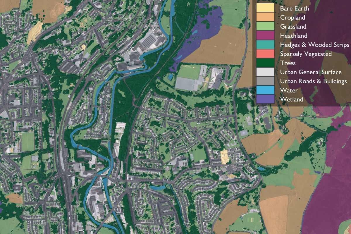
    Ordnance Survey has launched OS Enhanced Land Cover (ELC) Beta, a national habitat-mapping dataset that fuses OS National Geographic Database topography, OS aerial imagery, OS Terrain 5 and third-party sources including Natural England’s Living England, the Rural Payments Agency’s Crop Map of England and UKHab classifications to support 10% Biodiversity Net Gain (BNG) assessments. The tool enables desktop and field workflows for ecologists and developers, with Wessex Water using it via Linckia’s ESRI-based Habitat Fabric platform to assess hundreds of sites in a single spatial view. Linckia reports a 40% cut in data processing costs versus previous methods, rising to 90% compared with processing raw imagery, with OS claiming time savings of days to weeks per development across 1.5 million homes in the pipeline.

    Technical Brief

    • OS Enhanced Land Cover (ELC) Beta is explicitly aligned to the UKHab habitat classification standard.
    • UKHab alignment means outputs directly feed the statutory biodiversity metric required under Defra’s BNG legislation.
    • ELC aggregates OS National Geographic Database topography, OS aerial imagery and OS Terrain 5 into one habitat layer.
    • Third‑party inputs include Natural England’s Living England and the Rural Payments Agency’s Crop Map of England.
    • Wessex Water applies ELC via Linckia’s Habitat Fabric to inform 30‑year biodiversity uplift projections across its estate.
    • Linckia delivers ELC through an ESRI‑based BNG application, adding ecology rulesets on top of OS basemaps.
    • Reported cost savings are 40% versus earlier processed‑data workflows, and up to 90% versus raw imagery processing.
    • OS positions ELC as a way to relieve ecologist capacity constraints created by government home‑building targets plus BNG law.

    Our Take

    This is one of only a handful of Software pieces in our coverage where Ordnance Survey tools are being used directly to operationalise statutory environmental targets in England, complementing earlier OS work on climate-driven flood risk mapping for strategic transport corridors.

    The 10% biodiversity uplift target over a 30‑year projection period, combined with reported 40–90% reductions in data processing costs, signals that local authorities and utilities in the UK are likely to treat OS-aligned BNG datasets as a de facto standard for costed biodiversity accounting in housing pipelines of over a million units.

    Given Defra, Natural England and the Rural Payments Agency are all named, this OS BNG mapping product effectively sits at the intersection of regulatory compliance and geospatial software, suggesting that future Software-category tools in the UK will need to interoperate with these datasets to be credible for BNG reporting on construction projects.

    Geotechnical Software for Modern Teams

    Centralise site data, logs, and lab results with GEODB-io, CMRR-io, and HYDROGEO-io.

    No credit card required.

    • Save and export unlimited calculations
    • Advanced data visualisation
    • Generate professional PDF reports
    • Cloud storage for all your projects

    Prepared by collating external sources, AI-assisted tools, and Geomechanics.io’s proprietary mining database, then reviewed for technical accuracy & edited by our geotechnical team.
    Related Articles

    ABAX Tachograph for light vans: SMT2 compliance and data workflow notes for fleets
    Software
    5 days ago

    ABAX Tachograph for light vans: SMT2 compliance and data workflow notes for fleets

    ABAX has launched ABAX Tachograph to bring 2.5–3.5‑tonne light commercial vehicles into compliance with the EU Mobility Package’s Smart Tachograph 2 (SMT2) rules taking effect on 1 July for international transport. The system integrates LCVs and existing HGVs on a single Smart Operations platform, adding automated tachograph data downloads, violation analysis and driver data management rather than a separate standalone unit. ABAX is targeting fleets facing the 2026 full compliance deadline, aiming to simplify cross‑border operations and reduce manual admin around drivers’ hours enforcement.

    Liebherr extends MyLiebherr digital services: fleet data insights for engineers
    Software
    5 days ago

    Liebherr extends MyLiebherr digital services: fleet data insights for engineers

    Liebherr is rolling out its expanded MyLiebherr Performance and MyLiebherr Maintenance digital services for earthmoving and material handling fleets in Australia, the UK, Ireland, Canada and the USA, with six months’ free access. The maintenance module gives workshop managers a fleet-wide status overview with traffic light condition coding, cause-specific alerts (e.g. upcoming services, low fluid levels), machine-level service histories and geo-tracked locations to plan bundled interventions. The performance module tracks utilisation, idle hours, fuel consumption versus a global average, and weighing data, enabling group comparisons by machine type or operation to tighten scheduling and cut operating costs.

    Munnelly’s Weston Analytics hire: data-led logistics strategy for project teams
    Software
    6 days ago

    Munnelly’s Weston Analytics hire: data-led logistics strategy for project teams

    Munnelly Group has appointed former Heathrow and Wilson James executive Tom Emery as managing director of Weston Analytics to accelerate its technology, data and innovation strategy across construction logistics and project delivery. Emery, who has led large operational portfolios and digital transformation in aviation, transport, security and workforce operations, will build scalable digital and analytical tools to support faster operational decision-making and better use of site and programme data. CEO Paul David Munnelly said Weston Analytics is central to the group’s Target2030 plan and its role as a full project lifecycle delivery partner.

    Related Industries & Products

    Construction

    Quality control software for construction companies with material testing, batch tracking, and compliance management.

    QCDB-io

    Comprehensive quality control database for manufacturing, tunnelling, and civil construction with UCS testing, PSD analysis, and grout mix design management.