Geomechanics.io

  • Free Tools
Sign UpLog In

Geomechanics.io

Geomechanics, Streamlined.

© 2026 Geomechanics.io. All rights reserved.

Geomechanics.io

CMRR-ioGEODB-ioHYDROGEO-ioQCDB-ioFree Tools & CalculatorsBlogLatest Industry News

Industries

MiningConstructionTunnelling

Company

Terms of UsePrivacy PolicyLinkedIn
    Projects
    Sustainability
    Safety

    Helicopter mine remediation at Nant y Mwyn: design and water quality notes for engineers

    April 9, 2026|

    Reviewed by Tom Sullivan

    Helicopter mine remediation at Nant y Mwyn: design and water quality notes for engineers

    First reported on The Construction Index

    30 Second Briefing

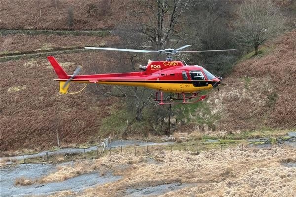
    Natural Resources Wales and the Coal Authority’s Mining Remediation Authority used a PDG helicopter to place 109 bags of stabilisation material along the Nant y Bai riverbank at Nant y Mwyn lead mine, Carmarthenshire, where about 300m³ of spoil was at immediate risk of being washed into the river. The airlift avoided haul roads and heavy plant, limiting ground disturbance and allowing follow‑up hand work to protect rare grassland around the site. Reducing severe spoil erosion is expected to cut cadmium and zinc loading to the Afon Tywi, currently elevated for up to 25 km downstream.

    Technical Brief

    • Nant y Mwyn remediation forms part of the Welsh Government-funded Wales Metal Mines Programme for high-risk legacy sites.
    • Severe spoil erosion along Nant y Bai currently contributes several tonnes of metal contaminants annually to the Afon Tywi.
    • Elevated cadmium and zinc concentrations persist for up to 25 km downstream of the mine, indicating chronic water-quality exceedances.
    • Works were deliberately scheduled before lambing and bird-nesting seasons to comply with ecological timing constraints.
    • Hand placement of materials was mandated in sensitive zones to protect rare grassland and heritage features from mechanical damage.
    • Similar abandoned metal mine sites with steep river-adjacent spoil heaps could adopt helicopter placement to meet strict habitat protections.

    Our Take

    The use of helicopter placement for stabilising material at Nant y Mwyn Mine suggests access or ground-stability constraints severe enough that conventional earthmoving would pose higher safety or erosion risk, a pattern also seen in other steep or highly weathered former metal mines in our database.

    With cadmium and zinc both flagged in the 173 keyword-matched pieces, this incident reinforces that legacy polymetallic lead sites in the United Kingdom often require multi-contaminant strategies rather than single-metal clean-ups, influencing how programmes such as The Wales Metal Mines Programme scope future works and budgets.

    Geotechnical Software for Modern Teams

    Centralise site data, logs, and lab results with GEODB-io, CMRR-io, and HYDROGEO-io.

    No credit card required.

    • Save and export unlimited calculations
    • Advanced data visualisation
    • Generate professional PDF reports
    • Cloud storage for all your projects

    Prepared by collating external sources, AI-assisted tools, and Geomechanics.io’s proprietary mining database, then reviewed for technical accuracy & edited by our geotechnical team.

    Related Articles

    Jacobs’ Oldbury environmental baselining: implications for nuclear site design
    Environmental
    3 days ago

    Jacobs’ Oldbury environmental baselining: implications for nuclear site design

    Jacobs has been appointed by Great British Energy – Nuclear to deliver environmental consultancy and baselining at the Oldbury site in Gloucestershire, earmarked as a potential location for a new nuclear power station. The work will characterise existing ground, groundwater, ecological and radiological conditions to support future nuclear site licensing, environmental permits and design optioneering. Early baselining data will be critical for later geotechnical investigations, foundation design, flood and coastal risk assessments, and long-term monitoring strategies if the project proceeds.

    UK Government NbS catchment study: hydrological design notes for engineers
    Environmental
    14 days ago

    UK Government NbS catchment study: hydrological design notes for engineers

    A UK Government research paper concludes that Nature-based Solutions such as floodplain reconnection, riparian woodland and leaky barriers are most effective when planned and modelled across whole catchments rather than as isolated site schemes. The study stresses integrating NbS with existing hard defences, using hydrological and hydraulic modelling to quantify peak flow attenuation and downstream level reductions under design storm events. For civil and drainage engineers, this points to earlier basin-scale option appraisal, multi-landowner agreements and long-term monitoring of storage volumes, infiltration rates and sediment behaviour.

    Dalton Quarry biodiversity bank: BNG design and land-take notes for project teams
    Environmental
    17 days ago

    Dalton Quarry biodiversity bank: BNG design and land-take notes for project teams

    A former Ibstock extraction site, Dalton Quarry, is being converted by Green Earth Developments Group into a biodiversity “bank” of engineered habitats to generate tradable biodiversity net gain (BNG) units for UK infrastructure schemes. The project will create a mosaic of habitat types on previously worked quarry land, allowing developers to purchase pre-accredited BNG units rather than delivering all ecological uplift within constrained project footprints. For civil and geotechnical teams, this model could influence land-take, earthworks design and long-term aftercare obligations on major road, rail and housing projects.

    Related Industries & Products

    Mining

    Geotechnical software solutions for mining operations including CMRR analysis, hydrogeological testing, and data management.

    CMRR-io

    Streamline coal mine roof stability assessments with our cloud-based CMRR software featuring automated calculations, multi-scenario analysis, and collaborative workflows.

    HYDROGEO-io

    Comprehensive hydrogeological testing platform for managing, analysing, and reporting on packer tests, lugeon values, and hydraulic conductivity assessments.

    GEODB-io

    Centralised geotechnical data management solution for storing, accessing, and analysing all your site investigation and material testing data.

    AllGeotechnicalMiningInfrastructureMaterialsHazardsEnvironmentalSoftwarePolicy