Geomechanics.io

  • Free Tools
Sign UpLog In

Geomechanics.io

Geomechanics, Streamlined.

© 2026 Geomechanics.io. All rights reserved.

Geomechanics.io

CMRR-ioGEODB-ioHYDROGEO-ioQCDB-ioFree Tools & CalculatorsBlogLatest Industry News

Industries

MiningConstructionTunnelling

Company

Terms of UsePrivacy PolicyLinkedIn
    AllGeotechnicalMiningInfrastructureMaterialsHazardsEnvironmentalSoftwarePolicy
    Failure
    Safety

    Devon A379 coastal erosion failure: funding and design lessons for engineers

    March 26, 2026|

    Reviewed by Tom Sullivan

    Devon A379 coastal erosion failure: funding and design lessons for engineers

    First reported on New Civil Engineer

    30 Second Briefing

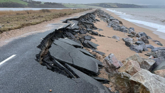
    Coastal erosion has destroyed a section of the A379 Slapton line in Devon, severing a key coastal route, but central government has offered only sympathy and no funding or technical commitment to reinstate it. The community, which depends on the road as the primary link between Kingsbridge and Dartmouth, now faces long diversion routes on minor inland roads not designed for current traffic volumes or heavy vehicles. For geotechnical and coastal engineers, the situation signals continued uncertainty over who funds long-term adaptation of low-lying coastal highways exposed to accelerating shoreline retreat.

    Technical Brief

    • Failure mechanism involves marine undercutting and beach drawdown leading to loss of toe support beneath the carriageway.
    • Geotechnical investigation would typically combine LiDAR change detection, beach profile surveys and boreholes through the former road alignment.
    • Continuous monitoring should prioritise real-time GNSS prisms, inclinometer arrays in remaining embankments and wave-buoy linked early-warning thresholds.
    • Any reinstatement would need coastal defence options appraisal (set-back realignment, rock armour revetment, sea wall) with life-cycle costing.
    • Design would be governed by wave loading, storm return periods and accelerated sea-level rise allowances under current UK guidance.
    • Temporary traffic management on diversionary minor roads requires structural assessment of pavements, weak bridges and constrained junction geometry.
    • Risk assessments must address emergency response access times, school transport and abnormal load routing under highway authority safety duties.
    • Similar low-lying coastal links will increasingly require pre-agreed managed realignment corridors and safeguarded inland route corridors in local plans.

    Our Take

    The lack of central government support in this Devon case suggests that UK local authorities will increasingly need to justify higher upfront resilience spend in their own budgets, rather than relying on post-failure funding, which has been a recurring tension in other UK Safety- and Failure-tagged items.

    Because New Civil Engineer also fronts awards and innovation programmes such as the British Construction & Infrastructure Awards and TechFest, this kind of Devon erosion failure is likely to feed into future calls for entries around low-cost coastal protection, managed retreat design, and lifecycle risk management for secondary roads.

    Geotechnical Software for Modern Teams

    Centralise site data, logs, and lab results with GEODB-io, CMRR-io, and HYDROGEO-io.

    No credit card required.

    • Save and export unlimited calculations
    • Advanced data visualisation
    • Generate professional PDF reports
    • Cloud storage for all your projects

    Prepared by collating external sources, AI-assisted tools, and Geomechanics.io’s proprietary mining database, then reviewed for technical accuracy & edited by our geotechnical team.

    Related Articles
    Melbourne sinkhole investigations: geotechnical lessons for tunnel project teams
    Hazards
    in about 1 month

    Melbourne sinkhole investigations: geotechnical lessons for tunnel project teams

    A sinkhole roughly 8–10 m wide and several metres deep has opened on the AJ Burkitt Reserve sporting oval in Heidelberg, directly adjacent to the North East Link tunnel alignment in Melbourne’s northeast. Victorian Infrastructure Delivery Authority has confirmed the “surface hole” is in the vicinity of active tunnelling operations, leading to a work pause while engineers and emergency crews carry out geotechnical investigations and monitoring. No injuries or structural damage have been reported, but the area remains fully cordoned off pending cause determination and stability assessment.

    Nepal’s Himalayan settlements: flood and landslide risk lens for engineers
    Hazards
    5 days ago

    Nepal’s Himalayan settlements: flood and landslide risk lens for engineers

    Escalating extreme rainfall and glacial melt are driving more frequent floods and landslides in Nepal’s Himalayan districts, with Karnali Province’s steep, highly fractured slopes and narrow river valleys particularly exposed. Recent events include debris flows cutting off road access to remote settlements and riverbank erosion undermining gabion walls and informal river training works along the Karnali and Bheri rivers. Engineers are being pushed towards slope stabilisation with bioengineering, improved drainage, and relocation or elevation of critical infrastructure away from active channels and unstable colluvium.

    CCC and ICE climate adaptation warning: design priorities for UK engineers
    Hazards
    6 days ago

    CCC and ICE climate adaptation warning: design priorities for UK engineers

    The Climate Change Committee warns that the “British way of life” faces escalating risk from heat, flooding and drought, with the Institution of Civil Engineers backing calls for rapid, large‑scale adaptation of UK infrastructure. Priority actions flagged include upgrading urban drainage and flood defences for more intense cloudbursts, retrofitting buildings for sustained 40°C heat, and securing water supply resilience against multi‑year droughts. For civil and geotechnical engineers, this signals imminent pressure to redesign assets for higher hydraulic loads, thermal stresses and soil moisture variability within the next planning cycle.

    Related Industries & Products

    Construction

    Quality control software for construction companies with material testing, batch tracking, and compliance management.

    Mining

    Geotechnical software solutions for mining operations including CMRR analysis, hydrogeological testing, and data management.

    QCDB-io

    Comprehensive quality control database for manufacturing, tunnelling, and civil construction with UCS testing, PSD analysis, and grout mix design management.