Alaska 2025 glacier‑linked megatsunami: hazard lessons for fjord engineers
Reviewed by Joe Ashwell
First reported on Geoengineer.org – News
30 Second Briefing
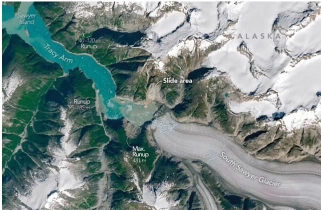
A 10 August 2025 rockslide in Alaska’s Tracy Arm Fjord sent more than 64 million m³ of rock and debris into the water, generating a megatsunami with an estimated maximum run-up of about 481 m along the steep fjord walls, the second-highest recorded after Lituya Bay 1958. The failure was linked to support loss from South Sawyer Glacier’s retreat, with the narrow fjord geometry strongly amplifying wave heights. No casualties occurred, but the near miss for cruise traffic signals a rising landslide–tsunami hazard in deglaciating fjords that must be factored into navigation and infrastructure risk assessments.
Technical Brief
- Failure mechanism involved a 64 million m³ rock–debris slide from a de-buttressed, glacier-adjacent valley wall.
- Glacier retreat of South Sawyer removed lateral support, increasing driving stresses and daylighting unfavourably oriented discontinuities.
- Confined fjord geometry produced strong wave focusing; run-up mapping relied on stripped-vegetation limits along steep walls.
- Monitoring implications include systematic remote sensing of deglaciating rock slopes and time-series InSAR to detect accelerating creep.
- For hazard zoning, results support coupling glacier-retreat scenarios with 3D landslide–tsunami numerical models for design-level events.
Our Take
Within our 32 Hazards stories, Alaska and Greenland fjord settings recur as outliers for extreme run-up events, suggesting that glacier-retreat slopes like Tracy Arm and South Sawyer Glacier warrant more systematic remote monitoring than typical coastal hazard programmes receive in the lower 48 United States.
The documented 64 million cubic metres landslide volume at Tracy Arm is in the same order as other recent rockslide–tsunami cases in our database, which implies that design criteria for critical infrastructure and cruise traffic in narrow fjords may need to assume near-worst-case slope failures rather than relying on historical wave records alone.
The link to a 2018 study on glacier-melt landslide tsunamis and a 2024 rockslide megatsunami study indicates that, in our coverage, research on cryosphere-driven slope instability is moving from theoretical risk to event-backed calibration, giving practitioners in Alaska and the wider Arctic/sub-Arctic a stronger basis for probabilistic hazard zoning.
Prepared by collating external sources, AI-assisted tools, and Geomechanics.io’s proprietary mining database, then reviewed for technical accuracy & edited by our geotechnical team.
Related Articles

Related Industries & Products
Mining
Geotechnical software solutions for mining operations including CMRR analysis, hydrogeological testing, and data management.
Construction
Quality control software for construction companies with material testing, batch tracking, and compliance management.
CMRR-io
Streamline coal mine roof stability assessments with our cloud-based CMRR software featuring automated calculations, multi-scenario analysis, and collaborative workflows.
HYDROGEO-io
Comprehensive hydrogeological testing platform for managing, analysing, and reporting on packer tests, lugeon values, and hydraulic conductivity assessments.
GEODB-io
Centralised geotechnical data management solution for storing, accessing, and analysing all your site investigation and material testing data.