Geomechanics.io

  • Free Tools
Sign UpLog In

Geomechanics.io

Geomechanics, Streamlined.

© 2026 Geomechanics.io. All rights reserved.

Geomechanics.io

CMRR-ioGEODB-ioHYDROGEO-ioQCDB-ioFree Tools & CalculatorsBlogLatest Industry News

Industries

MiningConstructionTunnelling

Company

Terms of UsePrivacy PolicyLinkedIn
    AllGeotechnicalMiningInfrastructureMaterialsHazardsEnvironmentalSoftwarePolicy
    Research
    Safety
    Sustainability

    83% of Britain’s cities heat‑vulnerable: design implications for civil engineers

    September 8, 2026|

    Reviewed by Joe Ashwell

    83% of Britain’s cities heat‑vulnerable: design implications for civil engineers

    First reported on New Civil Engineer

    30 Second Briefing

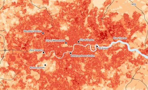
    Eighty-three per cent of Britain’s cities – 59 urban areas – are classed as highly vulnerable to urban heat in new spatial analysis by Ordnance Survey, the Met Office and 4 Earth Intelligence. The dataset combines OS building footprints, surface cover and green space with Met Office temperature projections to map local heat exposure at street-block scale. For civil and geotechnical engineers, this points to urgent retrofit of shading, permeable and high-albedo surfaces, and revised pavement and rail design to cope with more frequent extreme surface temperatures.

    Technical Brief

    • Designers can target tree planting, shading structures and surface material changes to specific high-exposure blocks, not whole boroughs.
    • Safety planning can prioritise cooling centres, shaded pedestrian routes and worker heat-stress controls in mapped hotspots.
    • Dataset supports compliance reviews against workplace heat-stress guidance and emerging building overheating regulations.
    • Scope is limited to Britain’s cities; rural settlements, villages and isolated infrastructure corridors are not characterised.

    Our Take

    Ordnance Survey’s urban heat work sits alongside its recent climate-driven flood risk mapping for England’s strategic roads and railways, signalling that OS and New Civil Engineer are increasingly framing climate hazards as an integrated infrastructure-planning problem rather than isolated events.

    The OS Enhanced Land Cover (ELC) Beta habitat-mapping dataset referenced in our coverage gives local authorities in Britain a ready-made spatial layer to cross-check where high urban heat vulnerability overlaps with limited green or blue infrastructure, which is critical for targeting cooling interventions.

    Geotechnical Software for Modern Teams

    Centralise site data, logs, and lab results with GEODB-io, CMRR-io, and HYDROGEO-io.

    No credit card required.

    • Save and export unlimited calculations
    • Advanced data visualisation
    • Generate professional PDF reports
    • Cloud storage for all your projects

    Prepared by collating external sources, AI-assisted tools, and Geomechanics.io’s proprietary mining database, then reviewed for technical accuracy & edited by our geotechnical team.

    Related Articles

    Egis appoints Jamie Gleave EIA director: implications for UK infrastructure teams
    Environmental
    11 days ago

    Egis appoints Jamie Gleave EIA director: implications for UK infrastructure teams

    Egis has appointed Jamie Gleave as senior environmental impact assessment technical director for the UK, bringing more than 25 years’ experience across energy, transport and water infrastructure, including Wylfa Newydd nuclear power station and National Grid electricity transmission schemes. Gleave previously served as EIA technical director at AECOM, where he led its global EIA technical excellence practice and directed environmental work on the A428 Black Cat to Caxton Gibbet and M42 Junction 6 DCO schemes, acting as expert witness. He will work with UK–Ireland head of environment Afshan Rasheed to build Egis’s EIA, DCO and technical assurance capability.

    United Utilities £900k sewage fine: CSO and storm capacity lessons for engineers
    Environmental
    14 days ago

    United Utilities £900k sewage fine: CSO and storm capacity lessons for engineers

    United Utilities has been fined £900,000 after admitting five environmental permit breaches linked to a major raw sewage discharge on the Fylde coast in June 2023, following failures in its wastewater treatment and overflow control systems. The incident involved untreated effluent bypassing normal screening and settlement processes during storm conditions, leading to prolonged discharge through combined sewer overflows into coastal waters used for bathing. For civil and environmental engineers, the case reinforces regulatory scrutiny on stormwater storage capacity, real-time CSO monitoring, and resilience of ageing sewer networks under intense rainfall events.

    Hinkley Point C transparency appeal: environmental data lessons for project teams
    Environmental
    17 days ago

    Hinkley Point C transparency appeal: environmental data lessons for project teams

    EDF’s Hinkley Point C nuclear project has applied for permission to appeal a tribunal decision that would bring the 3.2GW plant under Environmental Information Regulations, forcing greater disclosure of environmental data. The ruling, won by campaigners, could require release of detailed monitoring on coastal impacts, cooling water abstraction and construction emissions from major works such as the 900m seawater intake tunnels. Designers, contractors and consultants on similar large infrastructure schemes may face tighter scrutiny over environmental modelling assumptions, baseline data and ongoing performance reporting.

    Related Industries & Products

    Construction

    Quality control software for construction companies with material testing, batch tracking, and compliance management.

    Mining

    Geotechnical software solutions for mining operations including CMRR analysis, hydrogeological testing, and data management.

    CMRR-io

    Streamline coal mine roof stability assessments with our cloud-based CMRR software featuring automated calculations, multi-scenario analysis, and collaborative workflows.

    HYDROGEO-io

    Comprehensive hydrogeological testing platform for managing, analysing, and reporting on packer tests, lugeon values, and hydraulic conductivity assessments.

    GEODB-io

    Centralised geotechnical data management solution for storing, accessing, and analysing all your site investigation and material testing data.