National Grid north‑west Wales upgrade: design and phasing notes for engineers
Reviewed by Joe Ashwell
First reported on New Civil Engineer
30 Second Briefing
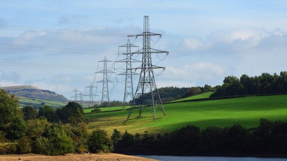
National Grid has lodged four planning applications to upgrade the high‑voltage transmission route between Pentir, near Bangor, and Trawsfynydd in north‑west Wales, a key corridor for moving power from existing and planned generation in Snowdonia. The works are expected to involve reinforcement of existing 400kV infrastructure, substation modifications and associated civil works along the existing wayleave rather than a completely new route. Geotechnical and civil teams should anticipate foundation strengthening, access upgrades and construction phasing constraints on an energised strategic asset.
Technical Brief
- Route runs between Pentir and Trawsfynydd, constraining works within an established North Wales transmission corridor.
- Multiple local planning authorities will need coordination, affecting consent conditions and construction programming.
- Existing access tracks and tower compounds may require temporary widening and surfacing upgrades for heavy plant.
- Interface with existing substations implies complex temporary earthing, protection changes and staged civil modifications.
Our Take
Within our 514 Infrastructure stories, National Grid features frequently in UK grid reinforcement pieces, signalling that the north‑west Wales submissions are part of a wider programme to unlock network capacity for renewables and new industrial loads rather than an isolated upgrade.
Multiple planning applications in one geography, as seen here around Pentir, Bangor and Trawsfynydd, usually indicate phased works across substations, overhead lines and cable routes, which can help National Grid manage outage risk and consenting timelines but complicates stakeholder coordination with local authorities and communities.
In our database, UK transmission upgrades in rural regions like north‑west Wales often face landscape and heritage constraints, so early clustering of four applications can be a tactic to present cumulative visual and environmental impacts upfront and reduce the risk of later legal challenge or redesign.
Prepared by collating external sources, AI-assisted tools, and Geomechanics.io’s proprietary mining database, then reviewed for technical accuracy & edited by our geotechnical team.


