Geomechanics.io

  • Free Tools
Sign UpLog In

Geomechanics.io

Geomechanics, Streamlined.

© 2026 Geomechanics.io. All rights reserved.

Geomechanics.io

CMRR-ioGEODB-ioHYDROGEO-ioQCDB-ioFree Tools & CalculatorsBlogLatest Industry News

Industries

MiningConstructionTunnelling

Company

Terms of UsePrivacy PolicyLinkedIn
    AllGeotechnicalMiningInfrastructureMaterialsHazardsEnvironmentalSoftwarePolicy
    Safety
    Projects

    Environment Agency drone squad: LiDAR enforcement lessons for waste engineers

    February 20, 2026|

    Reviewed by Tom Sullivan

    Environment Agency drone squad: LiDAR enforcement lessons for waste engineers

    First reported on The Construction Index

    30 Second Briefing

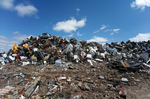
    Environment Agency drones are being deployed more aggressively against organised fly-tipping, with a 33-strong pilot squad logging 272 flight hours since July and preparing to carry light detection and ranging (LiDAR) payloads for high-resolution volumetric mapping of illegal waste sites. Moving LiDAR from manned aircraft to UAVs is intended to give prosecutors precise 3D evidence of waste locations and extents, while a new screening tool cross-checks lorry licence applications against waste permit records to flag suspect operators. Enforcement capacity has been boosted with the joint waste crime unit expanded from 13 to 20 staff, supporting 751 illegal sites shut and 221 prosecutions since March 2025 under a £15.6m enforcement budget.

    Technical Brief

    • Lidar currently flown from a dedicated manned aircraft primarily for national flood information capture.
    • Drone-captured 3D datasets are intended to be admissible courtroom evidence locating precise waste boundaries and volumes.
    • New screening tool cross-checks lorry licence applications directly against Environment Agency waste permit databases in real time.
    • Suspect haulage operators are algorithmically flagged before they obtain permissions to transport controlled waste streams.

    Our Take

    The Environment Agency and Defra feature together in several recent UK items in our database, signalling that waste enforcement and water regulation are increasingly being tackled as a joined-up compliance agenda rather than isolated policy strands.

    A 50% uplift to the Environment Agency’s £15.6m enforcement budget, combined with the expansion of the joint unit for waste crime, suggests operators on marginal or informal waste sites in the UK should now assume a materially higher probability of aerial detection and prosecution.

    With 751 illegal waste sites already shut in a record enforcement year, the use of drones for fly‑tipping surveillance is likely to spill over into monitoring of other land-use breaches, including unpermitted mineral extraction and stockpiling that fall under the ‘illegal mining’ incident category in our coverage.

    Geotechnical Software for Modern Teams

    Centralise site data, logs, and lab results with GEODB-io, CMRR-io, and HYDROGEO-io.

    No credit card required.

    • Save and export unlimited calculations
    • Advanced data visualisation
    • Generate professional PDF reports
    • Cloud storage for all your projects

    Prepared by collating external sources, AI-assisted tools, and Geomechanics.io’s proprietary mining database, then reviewed for technical accuracy & edited by our geotechnical team.

    Related Articles

    PFAS ‘forever chemicals’: design and risk implications for civil engineers
    Environmental
    1 day ago

    PFAS ‘forever chemicals’: design and risk implications for civil engineers

    Per- and polyfluoroalkyl substances (PFAS) are shifting from a niche contamination issue to a core design constraint for water, wastewater and brownfield infrastructure, as regulators tighten limits on “forever chemicals” in soil and groundwater. Civil engineers are being pushed to integrate PFAS-specific measures such as high-pressure membrane treatment, granular activated carbon and specialised landfill liners into drainage, flood defence and remediation schemes. The trend signals more complex risk assessments, higher lifecycle costs and potential redesign of legacy assets where PFAS-impacted leachate or run-off was not previously considered.

    UK sponge city strategies: design and SuDS lessons for civil engineers
    Environmental
    7 days ago

    UK sponge city strategies: design and SuDS lessons for civil engineers

    Sponge city strategies are gaining momentum in the UK as Ciwem’s recent Sponge Cities briefing note calls for widespread deployment of nature-based, water-retentive urban design. The concept centres on retrofitting streets, roofs and public spaces with permeable pavements, rain gardens, swales and green roofs to attenuate stormwater, reduce combined sewer overflows and manage surface water flooding. For civil and geotechnical engineers, this signals growing demand for SuDS-led masterplanning, hydraulic modelling of blue–green corridors and revised pavement and subgrade specifications to accommodate higher infiltration and storage.

    Managed aquifer recharge for UK floods and droughts: design notes for engineers
    Environmental
    12 days ago

    Managed aquifer recharge for UK floods and droughts: design notes for engineers

    Stormwater engineer David Schofield argues that large-scale managed aquifer recharge (MAR) using infiltration basins and recharge wells could simultaneously reduce UK surface-water flood peaks and bolster drought resilience. He points to schemes where storm flows are diverted from combined sewers into gravel-filled soakaways and deep injection wells, storing millions of cubic metres in permeable chalk and sandstone rather than building ever-larger attenuation tanks. For geotechnical and civil designers, MAR shifts focus towards subsurface storage capacity, soil permeability, groundwater mounding, and long-term water quality monitoring.

    Related Industries & Products

    Mining

    Geotechnical software solutions for mining operations including CMRR analysis, hydrogeological testing, and data management.

    CMRR-io

    Streamline coal mine roof stability assessments with our cloud-based CMRR software featuring automated calculations, multi-scenario analysis, and collaborative workflows.

    HYDROGEO-io

    Comprehensive hydrogeological testing platform for managing, analysing, and reporting on packer tests, lugeon values, and hydraulic conductivity assessments.

    GEODB-io

    Centralised geotechnical data management solution for storing, accessing, and analysing all your site investigation and material testing data.