Canada’s digital hub for mine permitting: practical insights for project teams
Reviewed by Tom Sullivan
First reported on MINING.com
30 Second Briefing
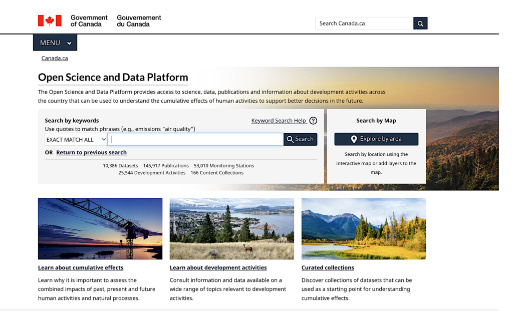
Canada’s Open Science and Data Platform (OSDP), built by Natural Resources Canada to support the federal Major Projects Office, is now central to mine permitting, aggregating geospatial science, environmental monitoring, mapping tools and regulatory records from federal, provincial and territorial sources into a single online portal. Used on Newmont’s Red Chris mine expansion in British Columbia’s Golden Triangle, the OSDP lets users layer Treaty boundaries, species-at-risk data, transmission lines, watersheds and nearby projects, with updates fed automatically via APIs rather than static uploads. NRCan reports about 200,000 unique users, 70% repeat visits, and is adding datasets by roughly 10% annually, with plans for AI-driven search and machine-readable historical assessments.
Technical Brief
- Interactive mapping allows stacking of roads, land cover, First Nation locations and monitoring stations for rapid spatial screening.
- Data remain live-linked to provincial and federal custodians via APIs, avoiding lag and version conflicts from static uploads.
- Junior explorers can pre-screen project descriptions using existing government environmental datasets, reducing early-stage baseline survey duplication.
- NRCan officials state users can assemble a multi-source project-area picture “within minutes”, supporting early constraints mapping.
- Future phases target AI-assisted search and metadata tagging plus OCR-style conversion of legacy assessments to machine-readable form.
- Any inclusion of Indigenous-owned datasets must comply with OCAP principles on ownership, control, access and possession.
Our Take
Natural Resources Canada is emerging as a systems-level actor in our database, pairing this permitting-focused software hub with recent capital injections into Teck’s Trail facility and the Malmbjerg molybdenum project, which suggests digital streamlining is being built alongside direct critical-minerals capacity investments.
With Canada’s mine timeline flagged at around 20 years, a permitting data hub is likely to matter most for multi-commodity regions like British Columbia’s Golden Triangle, where overlapping copper, gold and coal interests already feature in several NRCan-backed R&D and processing trials in our coverage.
The inclusion of gallium and other critical minerals in this platform aligns with NRCan’s recent support for germanium/gallium expansions at Teck’s operations, signalling that digital permitting tools may be calibrated first around projects tied to Canada’s strategic critical-minerals push rather than bulk commodities alone.
Prepared by collating external sources, AI-assisted tools, and Geomechanics.io’s proprietary mining database, then reviewed for technical accuracy & edited by our geotechnical team.
Related Articles



Related Industries & Products
Mining
Geotechnical software solutions for mining operations including CMRR analysis, hydrogeological testing, and data management.
CMRR-io
Streamline coal mine roof stability assessments with our cloud-based CMRR software featuring automated calculations, multi-scenario analysis, and collaborative workflows.
HYDROGEO-io
Comprehensive hydrogeological testing platform for managing, analysing, and reporting on packer tests, lugeon values, and hydraulic conductivity assessments.
GEODB-io
Centralised geotechnical data management solution for storing, accessing, and analysing all your site investigation and material testing data.